Remote Sensing
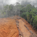
The Division generates spatial and temporal early warning information on food security and geo-hazards mapping enabling proper planning, management and informed decision-making whilst keeping an eye on and evaluating environmental changes, such as deforestation, urban development, land use changes and natural disasters. This is done through land use/land cover mapping, forest cover mapping, crop forecasting and food security and digital aerial photography. The crop forecasting and food security exercise is an annual program that targets the high and low potential counties in Kenya for growing maize and wheat and has been in operational since 1984. It applies remote sensing technology to predict production of maize and wheat well before harvest at national level. The division also provides periodic information on the status of the country’s water towers which is critical in the conservation and exploitation of the resources in a sustainable way.
The Remote sensing division leverages on earth observation data, airborne sensor systems, ultra-modern digital aerial photography technologies which include LiDAR scanning and hyperspectral sensing, to acquire very precise and high-resolution data on different thematic areas to provide solutions to the complex environmental challenges.